

Your flood zone determines what a lender requires. It does not determine whether your property can flood, and on a specific parcel it is sometimes simply wrong.
Both of those are worth understanding, because one affects how you think about risk and the other affects what you pay.
Zones are shown on Flood Insurance Rate Maps, available through the Flood Map Service Center by address.
A zones. High-risk areas subject to riverine or coastal flooding. AE is the most common and includes a published base flood elevation. A without a suffix means high risk with no detailed elevation determined. AO and AH indicate shallow flooding, typically sheet flow or ponding.
V zones. High-risk coastal areas additionally subject to wave action. VE includes a base flood elevation. These carry the most demanding construction requirements and the highest exposure.
X zones. Outside the high-risk area. Shaded X indicates a moderate-risk area, generally within the 0.2 percent annual chance floodplain. Unshaded X indicates minimal mapped risk.
D zones. Areas where no analysis has been done, meaning the risk is undetermined rather than low.
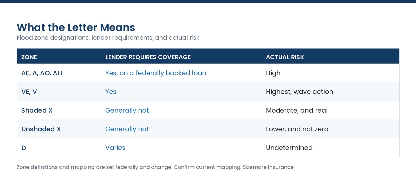
The takeaway: flooding regularly reaches property outside the high-risk zones, which is why the map tells you what a lender wants rather than what can happen.
Zone definitions and mapping are set federally and change. Confirm current mapping for your address.
Maps are drawn at a scale that cannot account for every parcel. A property on a rise inside a mapped zone is common, and there is a process for it.
A Letter of Map Amendment removes a structure or a parcel from the high-risk zone based on natural ground elevation, where a survey shows it sits above the base flood elevation.
A Letter of Map Revision based on fill does the same where the property was elevated with engineered fill.
A Letter of Map Revision changes the map itself, generally following a physical change or new engineering data, and is usually pursued by a community rather than an individual.
The first one is the one most owners can use.
What it requires: an elevation certificate or survey from a licensed surveyor or engineer, and an application. There is generally no fee for a standard amendment based on natural grade, and the survey costs what a survey costs.
What it changes: the lender requirement, and it can change your rate. It does not change whether water can reach the property, and I would keep coverage either way.
Removing the requirement is not the same as removing the risk. An owner who successfully amends out of a zone and then drops coverage has traded a mandate for an exposure. Keep the policy, at a lower rate.
Pricing is now property-specific, so an amendment may change your rate less dramatically than it once would have. Ask before spending on the survey.
Maps get updated, and a property can move into a zone as easily as out of one. Owners who carried coverage before a map change can receive more favorable treatment, which is one more argument for buying before you are required to.
A lender can require coverage regardless, by their own policy, even outside a mapped high-risk zone.
Your community's floodplain administrator is a genuinely useful resource and most owners never call them.
Multiple structures on a parcel can be zoned differently.
How do I find my flood zone?
Through the Flood Map Service Center by address, or ask us and we will pull it.
What does zone AE mean?
A high-risk area with a published base flood elevation, subject to the mandatory purchase requirement on a federally backed loan.
Is shaded X safe?
It is a moderate-risk designation, and property outside high-risk zones floods.
Can I get my property removed from a zone?
Sometimes, through a Letter of Map Amendment, where a survey shows the structure sits above the base flood elevation on natural grade.
Will an amendment lower my rate?
It can, and pricing is now property-specific so the effect varies. Ask before paying for the survey.
Should I drop coverage if I get removed?
No. The mandate changed and the water did not.
We have been an independent insurance company in North Carolina since 1977. Send us the address and we will pull the zone, quote it, and tell you whether an amendment is worth pursuing. Insurance made just for you.
Zone definitions, mapping, amendment procedures, and rating are set federally and are subject to change. Review your own situation with your advisor and your local floodplain administrator.