

Federal flood pricing used to work mostly off your zone. Two houses in the same zone paid similar amounts.
That changed. Pricing now reflects characteristics of the specific property rather than primarily the zone it sits in, and that is why two neighbors can pay very different premiums for what looks like the same risk.
Understanding what drives it tells you whether an elevation certificate is worth getting.
Distance to a flooding source. A creek, a river, a sound, or the ocean, and how far the structure sits from it.
Flood frequency and the types of flooding that affect the location, including river overflow, surge, and heavy rainfall.
The elevation of the structure relative to the expected flood level.
Foundation type, including whether the building is elevated, on a slab, or has a basement or crawlspace.
Replacement cost of the building, which affects what a loss would cost.
Prior claims on the property.
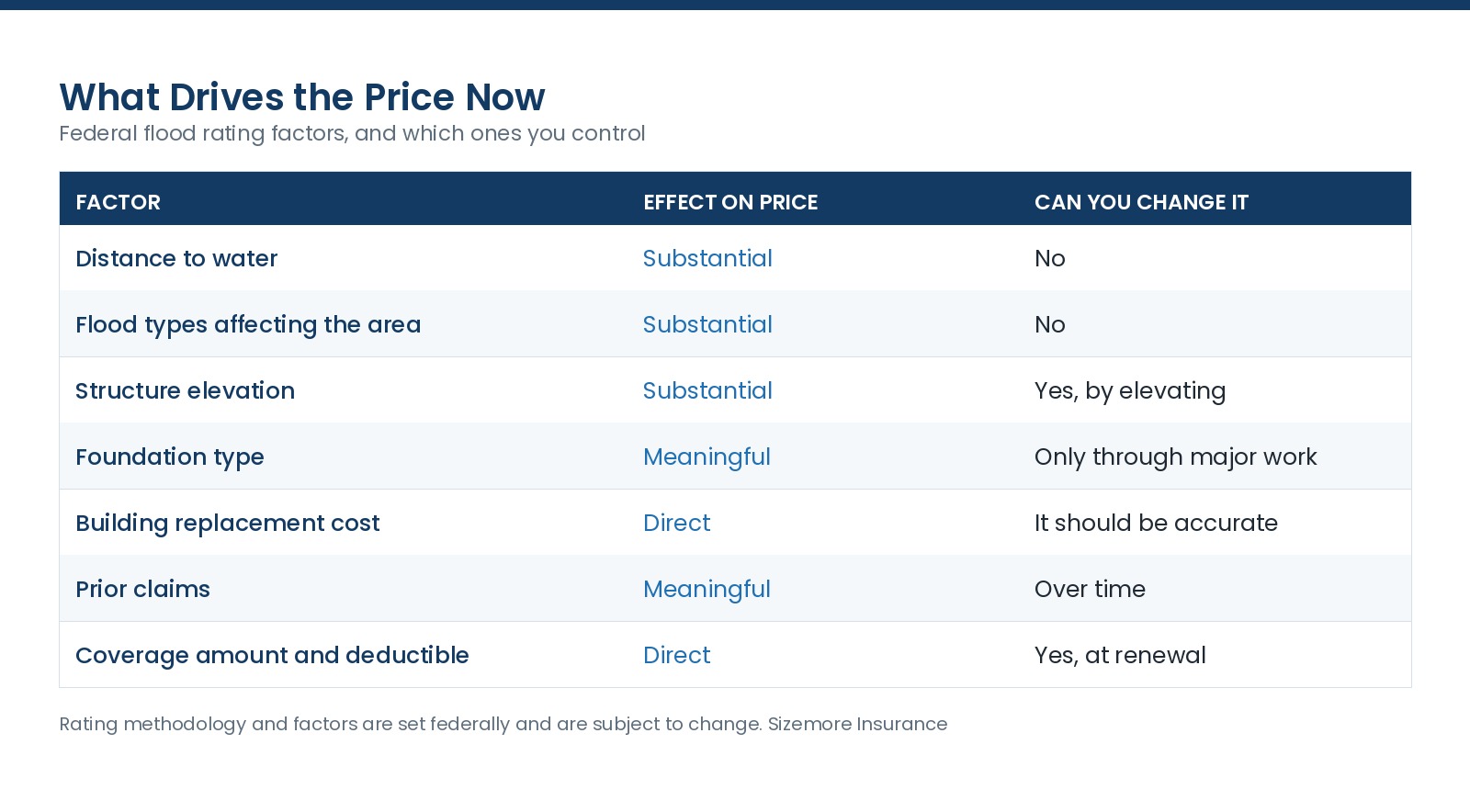
The takeaway: two of the largest factors are fixed by location and the third, elevation, is the one owners can change and document.
Rating methodology, factors, and program terms are set federally and are subject to change. Confirm current details.
An elevation certificate is a document prepared by a licensed surveyor or engineer recording the elevation of your structure relative to the base flood elevation.
Under the current methodology it is not required for federal rating the way it once was, and it can still change your price. Where a structure sits meaningfully higher than the expected flood level, documenting that is what lets a rate reflect it.
When it is clearly worth getting:
When it may not change much: a slab-on-grade house sitting at or below the expected flood level. The certificate documents a fact that does not help.
Private flood carriers use elevation differently than the federal program, and a certificate frequently matters more there. If you are comparing markets, having one strengthens the comparison.
Elevating a structure is a real option on some properties, and increased cost of compliance under the federal program can help fund it after a substantial damage event. That is covered separately in this section.
Grandfathering and continuous coverage interact with pricing when maps change, and that has its own article.
An inaccurate replacement cost raises your premium without adding coverage you can collect. Confirm it.
Deductible choices matter on flood the same way they do elsewhere, and they are frequently left at a default.
Community participation affects everyone in a town, through the Community Rating System, which is covered separately.
A certificate is a one-time cost and it does not expire in the way a policy does, though a substantial renovation can change what it documents.
What is an elevation certificate?
A document from a surveyor or engineer recording your structure's elevation relative to the base flood elevation.
Do I need one?
Not required for federal rating the way it once was. It can materially help where the structure sits high, and private carriers frequently use it.
How much does it cost?
It is a survey fee, which varies. Ask a local surveyor, and compare it against a year or two of premium difference.
Why do my neighbor and I pay different amounts?
Pricing reflects property-specific characteristics rather than primarily the zone, so distance to water, elevation, and foundation type all differ.
Can I lower my flood premium?
Elevation documentation, an accurate replacement cost, deductible choices, and community participation are the levers.
Does elevating my house help?
Substantially, and it is a major project. Increased cost of compliance can help fund it after a qualifying loss.
We have been an independent insurance company in North Carolina since 1977. Send us the address and we will quote it and tell you whether an elevation certificate is likely to pay for itself. Insurance made just for you.
Rating methodology, factors, and program terms are set federally and by private carriers and are subject to change. Review your own policy or talk to your advisor.